Invercargill's expansion southward onto the Makarewa and Oreti river terraces has pushed earthworks into terrain with distinct geotechnical challenges. The city's suburban growth through Grasmere and Waikiwi now intersects slopes underlain by Pliocene gravels and occasional peat lenses, where a standard cut can unravel if the pore-water regime is misunderstood. Our laboratory has run stability assessments for dozens of Southland projects over the years, building a dataset that connects back to the NZGS soil and rock slope management guidelines. Before you stake a boundary on sloping ground, a test pit investigation provides the shallow stratigraphy to anchor your model, and a triaxial test suite pins down the effective-stress strength envelope that governs long-term performance in Invercargill's saturated winter conditions.
Invercargill gravels can stand near-vertical through summer and then ravel out within a single wet week—timing the investigation to capture winter groundwater is what makes the model reliable.
Methodology applied in Invercargill
Local geotechnical conditions in Invercargill
A recent subdivision off Dunns Road cut a 6-metre face into weathered gravel with a thin silt seam at mid-height. The initial desktop model gave FoS 1.6, but after the first sustained rain the silt softened and triggered a translational block slide that pushed fill into the building platform below. The remediation cost ran well beyond what a staged investigation would have cost. The lesson we pass on to every Invercargill developer is that the gravel formation is not uniform—it carries interbedded fines that act as a perched water trap, and those layers rarely show in a single borehole log. A slope stability analysis that ignores the silt-smear horizon is just a desk exercise. We cross-check stratigraphy with test pits, then run drained and undrained scenarios so the contractor gets a clear trigger value for when pumping or flattening is needed before the cut advances.
Our services
Every Invercargill slope assessment we deliver is built around three linked work phases—field data collection, laboratory strength testing, and numerical modelling—so the output is a constructable design parameter set, not just a stability number.
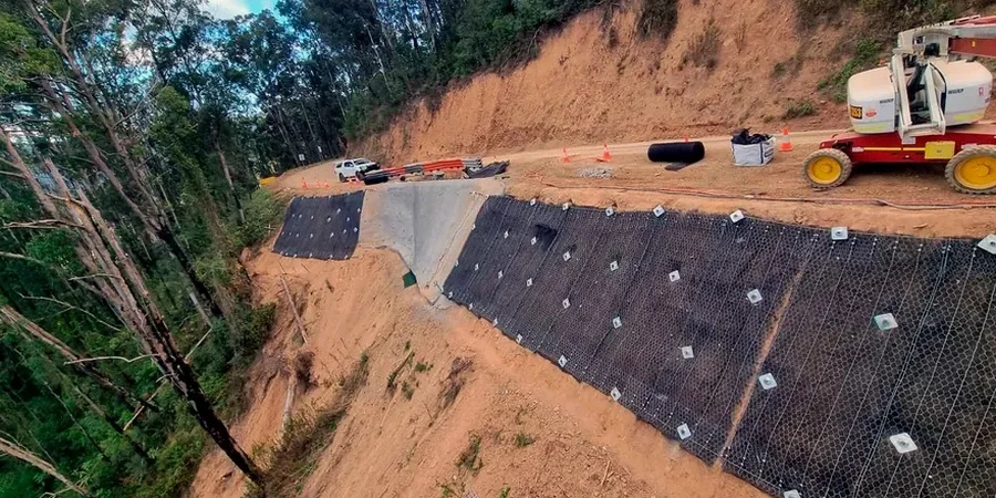
Limit-equilibrium stability modelling
Slide2 and RS2 models calibrated with site-specific groundwater observations for cuts, fills, and natural slopes across Invercargill's river-terrace terrain.
Effective-stress triaxial testing
IANZ-accredited consolidated-drained and consolidated-undrained triaxial tests on undisturbed gravel and silt samples to define the φ' and c' envelope used in the analysis.
Construction-phase verification and monitoring
Inclinometer and piezometer installation with trigger-level reporting so the earthworks contractor can manage cut progression safely through Invercargill's wet winters.
Quick answers
What is the typical cost of a slope stability analysis for a residential section in Invercargill?
For a single-dwelling cut in the Invercargill Gravel Formation, a desktop and field-based stability analysis generally ranges from NZ$1,830 to NZ$4,200 depending on access and the number of cross-sections. Larger subdivision or roading assessments that require triaxial testing and multiple groundwater monitoring rounds fall in the NZ$5,500–NZ$7,670 bracket.
Does Invercargill's seismic setting really influence slope stability?
Yes. With a hazard factor Z of 0.18 under NZS 4203, the seismic coefficient we apply to a pseudo-static analysis can reduce the factor of safety markedly, particularly on slopes steeper than 1H:1V. The NZGS guidelines require explicit consideration of earthquake-induced displacement for permanent slopes in this hazard zone.
How long does the analysis take from investigation to final report?
Site work and sampling typically take one to two days. Triaxial testing runs three to four weeks because of the saturation and consolidation stages required. The modelling and reporting phase is usually completed within two weeks of receiving the laboratory data, so a six-to-seven-week turnaround is realistic.
Can you assess an existing slope that is already showing tension cracks?
Absolutely. We prioritise distressed slopes. The investigation typically starts with a walkover survey and test pits to map the crack network, followed by rapid piezometer installation. The back-analysis uses the observed failure geometry to calibrate strength parameters, so the remedial design is grounded in actual performance rather than generic assumptions.