Invercargill's urban fabric spread south and east from the Oreti River through the early 1900s, swallowing dairy land, drained wetlands, and old shingle ridges as it grew. Much of the CBD and inner suburbs sit on Quaternary alluvium, but just a few metres down the story changes block by block. A row of shops on Dee Street can stand over compact gravel while the warehouse behind it floats on saturated peat. Developers who grew up here know the Murray Creek floodplain and the old seaward swamps don't give up their secrets easily. An exploratory test pit puts a geologist at the face of the excavation, measuring layer thickness, moisture state, and consistency with their own hands. It's the fastest way to ground-truth what the desk study suggests. When we open a pit near the old Star newspaper site or behind the velodrome, we often find lenses that borehole logs from the 1960s missed entirely. That kind of detail changes foundation decisions before the first concrete is ordered.
A shovel-cut face often tells you more about Invercargill's layered ground in ten minutes than a week of desk-study assumptions.
Methodology applied in Invercargill
Local geotechnical conditions in Invercargill
The most common mistake we see around Invercargill is treating a geotech report from a neighbouring site as valid for your own. A developer buys a section on the old Seaward Bush peat margin, borrows the neighbour's bore log, and pours a slab on-grade. The neighbour's log showed stiff clay at 1.2 m; the new site has fibrous peat at 400 mm. The slab cracks within two winters. An exploratory test pit on the actual footprint would have exposed the peat in an hour. The same goes for sites near the Oreti River's old meander channels: gravel ridges sit right next to backswamp clays, and a pit shows the transition in a single vertical face. Invercargill's shallow groundwater magnifies the risk. When you open a pit and it starts taking water at 1.2 m, you know straight away that any excavation below that level needs dewatering and that the bearing stratum will be saturated. That observation changes the compaction specification and the foundation type.
Our services
Our exploratory test pit work in Invercargill is designed to feed straight into the foundation design process. The field log, photographs, and bag samples all arrive at the same accredited laboratory that runs the index and strength testing, so nothing gets lost between the pit face and the report.
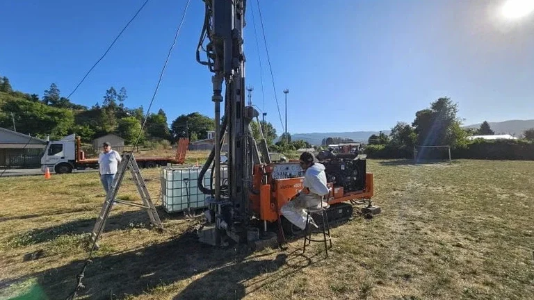
Machine-Excavated Test Pits
Tracked excavator pits to 4.5 m on greenfield and brownfield sites across Southland, with continuous logging of stratigraphy, moisture, and consistency by an engineering geologist at the face.
Pit-Floor Sampling and In-Situ Testing
Block samples, bag samples, and Shelby tubes taken from the pit floor and walls, coupled with hand vane shear and pocket penetrometer readings recorded on the log before backfill.
Combined Pit and Borehole Programs
Where depth exceeds safe pit excavation, we combine test pits with SPT drilling from the pit base, linking the visual upper profile to deeper strength data in a single coordinated investigation.
Quick answers
What does an exploratory test pit typically cost in the Invercargill area?
For a standard machine-excavated test pit with full geological logging, photographs, and sampling on an accessible Invercargill site, budget between NZ$880 and NZ$1,360 per pit. The final figure depends on depth, access for the excavator, traffic management if required, and the number of bag or block samples sent to the lab. We provide a fixed-price quote once we have seen the site plan and ground conditions.
How deep can you safely excavate a test pit in Invercargill?
We routinely excavate to 3.0–4.5 m with a 5-tonne excavator on firm ground. In loose sands or soft peat, depth is governed by sidewall stability and groundwater inflow. The WorkSafe excavation safety code applies, and we batter back the sides or use trench shields if the ground demands it.
What information does a test pit provide that a borehole cannot?
A test pit exposes a continuous vertical face, so you see layer boundaries, soil fabric, fissuring, root penetration, and moisture condition directly. You can photograph the face, take undisturbed block samples with a spade, and measure consistency with a hand vane right at the pit edge. A borehole gives you a core; a test pit gives you the whole picture.
Do you reinstate the ground after the test pit is logged?
Yes. We backfill in compacted lifts, typically with the excavated spoil unless the engineer specifies imported fill. Invercargill City Council consent conditions often require compaction records, which we supply as part of the field report.
Can a test pit be used instead of a borehole for a residential foundation design?
In many cases, yes, especially for single-storey residential or light commercial builds on shallow foundations. The test pit confirms the bearing stratum, identifies soft or organic layers, and records groundwater depth. If the proposed foundation depth exceeds safe pit depth, we combine the pit with SPT drilling from the pit base to extend the profile.