Invercargill sits at roughly 11 metres above mean sea level on deep Quaternary alluvial sediments, where the water table often lies within 2 metres of the surface. These conditions make Vertical Electrical Sounding a particularly useful first-pass investigation tool. A 2022 project near the Oreti River identified a buried paleochannel at 18 metres depth that conventional drilling had missed. Electrical resistivity surveys measure apparent resistivity across expanding electrode spreads, building a layered resistivity model that reveals changes in saturation, grain size, and salinity before any excavation begins. For sites near the New River Estuary, where saline intrusion can compromise shallow footings, we often combine VES with a CPT test to calibrate resistivity profiles against direct penetration data. The method works fast, covers large areas, and helps reduce the number of boreholes needed on large Southland subdivisions.
A resistivity profile across Invercargill’s alluvial plain can reveal a buried paleochannel that would take twenty boreholes to map.
Methodology applied in Invercargill
Local geotechnical conditions in Invercargill
A mistake we see repeatedly on Invercargill’s southern industrial subdivisions is relying solely on boreholes spaced 50 metres apart when the subsurface is a braided river deposit with metre-scale variability. A single borehole can miss a low-resistivity clay pocket that later causes differential settlement under a slab-on-grade. Electrical resistivity fills the gaps between boreholes, showing lateral and vertical transitions that point data cannot capture. The bigger risk is misidentifying a low-resistivity zone as groundwater when it is actually a saline clay lens—making excavation plans and drainage assumptions wrong from the start. Without a calibrated resistivity model, foundation designs may overestimate bearing capacity or underestimate settlement potential, leading to costly remedial work after the concrete is poured.
Our services
Our Invercargill resistivity surveys are delivered as part of integrated site investigation packages. Each service below can be combined with VES to produce a defensible ground model for council consent.
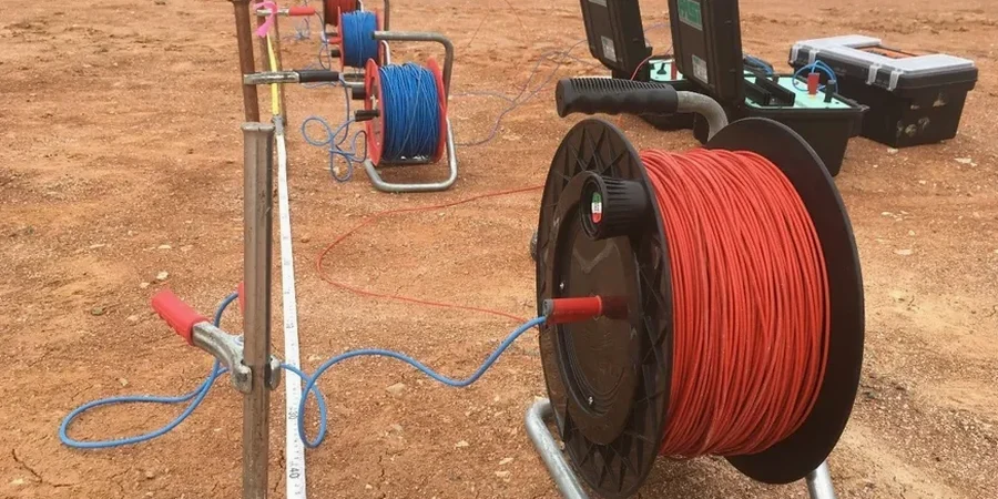
VES Profiling for Foundation Design
Schlumberger-array soundings to 30–50 m depth, calibrated against available borehole logs, to define bearing layer geometry and groundwater conditions across commercial and residential sites in Invercargill.
ERT 2D Imaging for Cut-and-Fill Projects
Multi-electrode resistivity tomography along proposed road alignments or building platforms, providing continuous cross-sections that highlight soft zones, peat pockets, or buried services.
Groundwater and Salinity Mapping
Targeted resistivity surveys near the New River Estuary and Oreti River margins to delineate freshwater-saltwater interfaces, supporting dewatering design and concrete durability assessments per NZS 3101 exposure classifications.
Quick answers
How much does a VES survey cost for a standard residential section in Invercargill?
For a typical residential lot, a Vertical Electrical Sounding survey with 3–5 soundings and a basic interpretative report ranges from NZ$1,030 to NZ$1,970, depending on access conditions, line clearance requirements, and whether we need to combine it with a test pit for calibration.
What depth can VES reach in Southland soils?
Investigation depth is controlled by the maximum current electrode spacing. With a 200-metre AB/2 spread, we can reliably resolve layers down to 50–70 metres in the alluvial sediments typical of the Invercargill basin, though resolution decreases with depth and the presence of conductive surface clays can limit penetration.
Can resistivity surveys distinguish between peat and soft clay?
Partially. Peat tends to show higher resistivity than saturated clay due to its organic content and gas pockets, but there is overlap. We calibrate resistivity profiles against at least one borehole or dynamic probe log so that the geophysical interpretation is tied to physical soil descriptions, following NZGS recommended practice.
Is VES accepted by Invercargill City Council for building consent?
Yes, resistivity data is routinely included in geotechnical investigation reports submitted to ICC. The key is that results must be interpreted by a qualified geotechnical engineer and, where necessary, calibrated with intrusive investigation methods to satisfy the requirements of the NZGS Guideline and the Building Code clause B1.